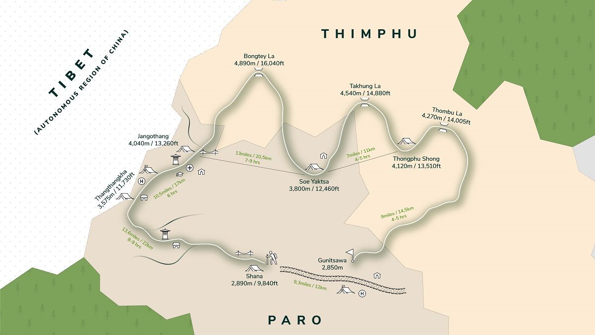
Bhutan Jomolhari Loop Trek is one of the most popular places for tourism in Bhutan. The Paro Valley extends from the confluence of the Wang and Paro Rivers at Chuzom Town all the way up to Mount Jomolhari.
Distance
59km
Difficulty
Moderate
Best Months to Trek
March to May
Description
What's Included
What's Excluded
-
 Visa for Bhutan
-
 Daily 3 meals (B/L/D) at designated restaurants or hotels
-
 Licensed English-speaking guide
-
 Entry fees & road permits
-
 Mineral bottled water
-
 Government fee, royalty, taxes & surcharges
Checklist
- Thick socks (2-4 pairs)
- Trekking boots
- Down jackets
- Sunglasses
- Lightweight towel
- Warm or sun hat
- Thermal wear
- Suns cream and lip balm
- Waterproof ¾ season jacket and trousers
- Camp Footwear (light shoes/trainers)
-
 Airport transfers
-
 Lent set of traditional costume
-
 Accommodation at 3 star hotel
-
 Private tour guide
-
 Full service & assistance before, during and after your Bhutan trip
Checklist
- Thick socks (2-4 pairs)
- Trekking boots
- Down jackets
- Sunglasses
- Lightweight towel
- Warm or sun hat
- Thermal wear
- Suns cream and lip balm
- Waterproof ¾ season jacket and trousers
- Camp Footwear (light shoes/trainers)
Accommodation and Meals
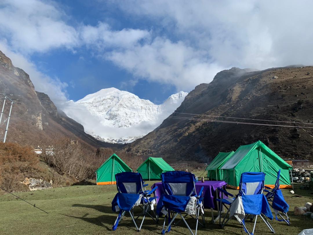
Like most of the trekking, the accommodation during the trek is mainly camping in tents. Bhutan does not have any commercial guesthouse along the trekking trail, as many of them are in remote areas and are in environmental regions that are protected from development.
All meals are included and prepared/catered by the cook and staff that will accompany you along the trail throughout the entire trekking period. On the trek you are assisted by your local guide, a cook, 2-3 helping staff/porters depending upon the group size.
Important Notes
- A good level of fitness is necessary
- Trek is not suitable for children aged under 13
- Not suitable for those with a respiratory, cardiac, or circulatory disorder or a disability that limits mobility


Jomolhari Loop Trek (Soi Yaktsa) Itinerary
6 Days
Shana Zampa (2890 m) - Thangthangkha (3610 m)
The distance required to cover is 22 Km which usually takes about 7-8 hours. The trail continues with lots of small ascents 770 m and descent 10 m.
The trail follows the river through a heavily forested area with a few isolated farmhouses. As we go up the valley becomes narrow, wilder and steeper. The trail winds up and down along the drainage.
We pass a junction en-route, where another path leads over the Tremo La to Tibet. This route was formerly used by Bhutanese people as a trading route to Tibet.
We will cross several traditional wooden bridges finally arriving at Thanthangka. The camp is in a meadow with a stone shelter. From this campsite for the first time in case of good weather, Mount Jomolhari may be seen. The campsite is located at an altitude of 3610 meters.
Highlight
The trail follows the river through a heavily forested area with a few isolated farmhouses. As we go up the valley becomes narrow, wilder and steeper. The trail winds up and down along the drainage.
Thangthangkha (3610 m) to Jangothang (4080 m)
Today you will be trekking along Paro Chhu and will pass through quaint villages Takethang, Dangochange and Soe.
The distance to cover today is 19 Km which usually takes about 5-6 hour. The trails ascent 480 m. The path ascends for a while until we reach the army camp. We then follow the river above the treeline, enjoying stunning views of the surrounding peaks. Hot lunch is served at a yak herder’s camp.
A short walk from here into the valley takes us to our campsite at Jangothang (4,080m). From here, the views of Jhomolhari and Jichu Drake are superb.
Highlight
A short walk from here into the valley takes us to our campsite at Jangothang (4,080m). From here, the views of Jhomolhari and Jichu Drake are superb.
Jangothang Halt
Jangothang is a perfect environment for your acclimatization. There are a number of day hikes with great views of lakes and snow-capped mountains. One can also spot some blue sheep on the upper slopes of the valley.
You can also trek up to Tosoh or hike around the area. There are good short hiking trails in three directions. Jomolhari and its subsidiary mountain chains lie directly west, Jichu Drake to the north and there are a number of unclimbed peaks to the east.
For Day hikes, you have 3 options on this day at Jangothang.
1. Hike to Jomolhari Glacier which is around 4 ½ hours (Back and forth)
2. Hike to Jichu Drake Glacier which is around 3 hours (Back and Forth).
3. Walk up the mountain between Jomolhari and Jichu Drake, the summit is at 5200 meters with a great view of both the mountains. This is 8 hours (Back and forth).
Highlight
Jangothang is a perfect environment for your acclimatization. There are a number of day hikes with great views of lakes and snow-capped mountains.
Jangothang (4080 m) - Soi Yaktsa (3800 m)
The distance required to cover is 16 Km which usually takes 6 - 7 hours, with ascent 810 m and descent 1090 m.
From Jangothang, you begin your return trip by another route heading south to form the entire loop. The trail leads to the last settlement in the valley and drops to the Paro Chhu.
The trail climbs up to the highest point of this trek, Bhonte La Pass, at 4,890 m after you passing the lakes of Tshophu (4,380 m), the high-altitude lakes are eminent for the inhabited ruddy shelducks and the deep-lake brown trout. Fascinating panoramic views of Jhomolhari, Jhomolhari 2, Jichu Drakye and Tserim Kang are along the trekking route.
Passing the lake, you start to trek downstream and eventually reach Soi Yaktsa (3,800 m), a spectacular valley with stunning views perfect for the campaign after you wind down a stretch of yak trail. Have a good rest at Soi Yaktsa to enjoy the rocky cliffs, meadows, wildflowers, and nomadic settlements.
Highlight
The trail climbs up to the highest point of this trek, Bhonte La Pass, at 4,890 m after you passing the lakes of Tshophu (4,380 m), the high-altitude lakes are eminent for the inhabited ruddy shelducks and the deep-lake brown trout. Fascinating panoramic views of Jhomolhari, Jhomolhari 2, Jichu Drakye and Tserim Kang are along the trekking route.
Soi Yaktsa (3800 m) - Thombu Shong (4180 m)
The distance required to cover is 11 Km which usually takes 4 - 5 hours, with ascent 720 m and descent 320 m.
Today the trail begins from an uphill climb after you pass a short stretch of trail with lush rhododendrons by the hillside. You still trek in forests of birch and oak after you arrive at a chorten and a mani wall.
You can choose to follow the mani wall and take an upward trail to a small valley where the trekking trail bifurcates, or you can choose to take a quick downward tour to the ruins of the Sey Dzong and then go back to the main trail to reach the small valley.
Pick the right track at the small valley to reach the Takhung La Pass (4,520 m). Spectacular views of Jomolhari, Jichu Drakye, and Tserim Kang appear again in all their splendours.
After the Takhung La Pass, the trail starts to descend till you arrive at Thombu Shong, green pasture with three yak herder huts scattering around. Your campsite is next to them which is at 4180 m.
Highlight
Thombu Shong (4,180 m) - Gunitsawa Village (2,930 m), Drive to Paro (2,200m)
The distance required to cover is 13 Km which usually takes 4 - 5 hours, with ascent 200 m and descent 1650 m.
Leaving the campsite, the trail begins to gain elevations to reach the Thombu La Pass (4,380 m) after you pass through a gorgeous garden festooned with beautiful wildflowers and flush rhododendron.
Passing the Thombu La, you will be guided by a steep downward route to Gunitsawa village (2,730 m), where the trek ends and drive to Paro for the night.
Highlight
Passing the Thombu La, you will be guided by a steep downward route to Gunitsawa village (2,730 m), where the trek ends and drive to Paro for the night.
Trekking Map