The Snowman Trek is an extension of the beautiful Laya Gasa Trek and leads from Laya into high altitudes of the Bhutanese Himalayas.
Distance
Difficulty
Strenuous
Best Months to Trek
Unlike other treks in Bhutan, the best time for Snowman Trek is summer (Mid June to Mid October).
Description
What's Included
What's Excluded
-
 Government fee, royalty, taxes & surcharges
-
 Licensed English-speaking guide
-
 Full service & assistance before, during and after your Bhutan trip
-
 Mineral bottled water
-
 Entry fees & road permits
-
 Accommodation at 3 star hotel
-
 Daily 3 meals (B/L/D) at designated restaurants or hotels
-
 Tour driver & vehicle
-
 Visa for Bhutan
-
 Private tour guide
Checklist
- Gaiters
- Camp Footwear (light shoes/sandals/trainers)
- Warm mid-layers (fleece/microfibre)
- Scarf/neck warmer
- Shorts
- Down jackets
- Suns cream and lip balm
- Warm Hat and sun Hat
- Trousers - Lightweight, loose-fitting, trekking trousers, pants with zip-off bottoms
- Thermal wear
- Tracksuit or fleece pants for evenings
- Sunglasses with UV protection
- Sleeveless fleece and extra layers for winter departures
- Warm or sun hat
- Gloves and Mitts - waterproof and warm
- T-Shirts
- Trekking boots
- Headlamp with extra batteries
- Waterproof ¾ season jacket and trousers
-
 Airport transfers
Checklist
- Gaiters
- Camp Footwear (light shoes/sandals/trainers)
- Warm mid-layers (fleece/microfibre)
- Scarf/neck warmer
- Shorts
- Down jackets
- Suns cream and lip balm
- Warm Hat and sun Hat
- Trousers - Lightweight, loose-fitting, trekking trousers, pants with zip-off bottoms
- Thermal wear
- Tracksuit or fleece pants for evenings
- Sunglasses with UV protection
- Sleeveless fleece and extra layers for winter departures
- Warm or sun hat
- Gloves and Mitts - waterproof and warm
- T-Shirts
- Trekking boots
- Headlamp with extra batteries
- Waterproof ¾ season jacket and trousers
Accommodation and Meals
Camping in extreme weather such as cold temperatures and snowy conditions can be expected and extremely enjoyable; Camping in the snow can be peaceful, picturesque and an outdoor adventure.
All the accommodation while on Trek is twin sharing, double occupancy. Single occupancy intents can be arranged on demand at an additional charge. All tents are Cold Weather Tents and designed for harsh weather and snowy conditions. Separate tents will be pitched for dining, kitchen and restroom.
Important Notes
- A good level of fitness is necessary
- Trek is not suitable for children aged under 13
- Not suitable for those with a respiratory, cardiac, or circulatory disorder or a disability that limits mobility
Provided on the trek:
- Sleeping tent
- Dining tent
- Kitchen tent
- Toilet tent
- Inflatable air mats or mattresses
- Carpets
- Hot water bags
- Table and chairs
- Sleeping bag liners and blankets
- Duffle bags
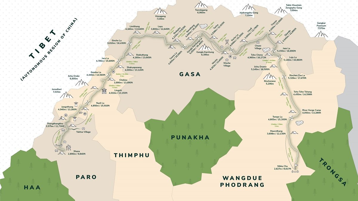
Snowman Trek I Itinerary
24 Days
Shana Zampa (2890 m) - Thangthangkha (3610 m)
The distance required to cover is 22 Km which usually takes about 7-8 hours. The trail continues with lots of small ascents 770 m and descent 10 m.
The trail follows the river through a heavily forested area with a few isolated farmhouses. As we go up the valley becomes narrow, wilder and steeper. The trail winds up and down along the drainage.
We pass a junction en-route, where another path leads over the Tremo La to Tibet. This route was formerly used by Bhutanese people as a trading route to Tibet.
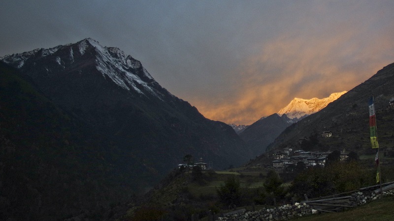
We will cross several traditional wooden bridges finally arriving at Thanthangka. The camp is in a meadow with a stone shelter. From this campsite for the first time in case of good weather, Mount Jomolhari may be seen. The campsite is located at an altitude of 3610 meters.
Highlight
The Trek starts from Shana Zampa in Paro, traverses along Tibet border and ends at Nika chhu zam in Trongsa.
Thangthangkha (3610 m) to Jangothang (4080 m)
Today you will be trekking along Paro Chhu and will pass through quaint villages Takethang, Dangochange and Soe.
The distance to cover today is 19 Km which usually takes about 5-6 hour. The trails ascent 480 m. The path ascends for a while until we reach the army camp. We then follow the river above the treeline, enjoying stunning views of the surrounding peaks. Hot lunch is served at a yak herder’s camp.
A short walk from here into the valley takes us to our campsite at Jangothang (4,080m). From here, the views of Jhomolhari and Jichu Drake are superb.
Highlight
We cross two high passes: Shingchen La pass 5005m and Ganglakarchung pass 5120m.
Jangothang Halt
Jangothang is a perfect environment for your acclimatization. There are a number of day hikes with great views of lakes and snow-capped mountains. One can also spot some blue sheep on the upper slopes of the valley.
You can also trek up to Tosoh or hike around the area. There are good short hiking trails in three directions. Jomolhari and its subsidiary mountain chains lie directly west, Jichu Drake to the north and there are a number of unclimbed peaks to the east.
For Day hikes, you have 3 options on this day at Jangothang.
-
Hike to Jomolhari Glacier which is around 4 ½ hours (Back and forth)
-
Hike to Jichu Drake Glacier which is around 3 hours (Back and Forth).
-
Walk up the mountain between Jomolhari and Jichu Drake, the summit is at 5200 meters with a great view of both the mountains. This is 8 hours (Back and forth).
Highlight
The highest camp altitude is 5050m, Average walking distance 17 km and Average walking time 9 hours.
Jangothang (4080 m) - Lingshi (4010 m)
The distance to be covered today is 18 Km with 840 m ascent and descent of 870 m and it will take about 6-7 hours.
It will be one of the longest days of the trek. A short distance from the camp the trail begins climbing rapidly for about half an hour and then becomes a gradual ascent to the Nyilila pass at 4870m. While on the climb enjoy the surroundings. You might see herds of blue sheep grazing on the slopes of the mountains.
From the pass you will have spectacular views of Mount Jomolhari, Jichu Drake and Tsherimgang, all of them rising above 7000m. It’s a gradual descent to the camp where you will pass by some yak herders’ tents, made from yak wool. The herders use these tents while travelling to various pastures for their yaks.
As you come down into the Lingshi basin, a beautiful U-shaped valley, you get a wonderful view of Lingshi Dzong on clear days. Tsherimgang and its glaciers rise up at the north end of the valley. The campsite is next to a stone hut you reach just before Lingshi Dzong at 4,010 m.
Highlight
Mountains seen are: Mount Jumolhari 7314m, Jichu Drake 6989m, Tsherimgang 6789m, Kangbum 6526m, Tiger Mountain 6840m and Tsenda Gang 7100m.
Lingshi (4010 m) - Chebisa (3880 m)
The distance to be covered today is 10 Km with 280 m ascent, 410 m descent which will take about 5-6 hours.
Shortly after starting you will reach a chorten below Lingshi Dzong. Here, you have the choice of staying on the main trail or taking a detour up to the Lingshi Dzong (4,220m), which sits right atop a high ridge. This Dzong is under reconstruction from a 2011 earthquake which damaged its central building.
In addition to a very special atmosphere of mystic tranquillity, Lingshi Dzong provides a great view over the valley. After Lingshi Dzong you will be passing the villages of Lingshi and Goyul.
In Goyul, the stone houses are clustered together to form a small compact village that is unusual in Bhutan where settlements are usually scattered. On reaching the campsite at Chebisa (388 m) you will have plenty of time to visit the village houses if you feel up to it. There is also a beautiful waterfall located behind the village that is worth visiting.
Highlight
Other attractions: high grazing meadows and pastures, snow-capped mountains, nomadic life, high passes and terrains.
Chebisa (3880 m) - Shomuthang (4220 m)
Today the distance to be covered is 17 Km with 890 m ascent and 540 m descent which will take about 6-7 hours.
The morning starts with a long ascent behind Chebisa Village (2-3 hours) through a wide pastureland towards Gobu La (pass). After crossing Gobu La (4,410m), you descend into the valley, then climb again a little bit, before descending again to Shakshepasa (3,980), a large U-shaped valley.
Climbing from here you will finally reach the campsite at Shomuthang, above a river, which is a tributary of the Nochu River.
Highlight
Shomuthang (4220 m) - Robluthang (4160 m)
The distance to be covered today is 18 Km with 700 m ascent and 760 m descent which will take about 6-7 hours.
We begin by climbing up the valley to view Kang Bum (6,526 m) and some edelweiss. After two hours of climbing you will reach Jhari La (4,750m), from where you catch the first glimpse of Sinche La, the pass you will have to cross the day after. The big snow peak in the north is Gangchhenta 6,840 m, better known as the Great Tiger Mountain.
If the weather is clear, Tserim Kang and the top of Jomolhari will be visible. The camp by the river is called Tsheri Jathang located in a beautiful wide and remote valley. Herds of takin, the Bhutanese National Animal, migrate to this valley in summer and remain for about four months.
The valley has been declared a takin sanctuary. Climb up a little bit and you will reach the campsite at Robluthang in a rocky meadow.
Highlight
Robluthang (4160 m) - Limithang (4140 m)
Today we will cover a distance of 19 Km with 850 m ascent, 870 descent which will take about 6-7 hours.
The trek starts out with an initial 40-60mins ascent before gradually raising for another 1.5 hours through a boulder field. It is then a 1-hour steep ascent before reaching Sinche La (5,005m) – the final and highest pass on the trek if you don’t intend to continue the Snowman trek from Laya onwards.
As you descend the far side of the pass you will see an impressive terminal moraine and a glacial lake at the foot of the valley. You can see classic examples of lateral moraines where the glacier has pushed rocks up both sides of the valley. Below the moraine, you cross the Kango Chhu and soon reach the Limithang campsite. The peak of Gangchhenta towers over the campsite even though it’s quite a distance away.
Highlight
Limithang (4140 m) - Laya (3840 m)
The distance to be covered today is 10 Km with 60 m ascent and 340 m descent which will take about 4-5 hours.
Today, you walk downhill all the way along a narrow, winding river valley. After a long time, the trail takes you through the densely forested region. The trail leads you to the west side of Laya village. From the west of the village, you will have spectacular views of Mt. Gangchhenta and catch Mt. Masagang.
In the village, the centre is a community school and a basic health unit with a telephone connection. The campsite is located below the school at 3840 m.
Highlight
Laya - Halt
Today we take it light and easy and acclimatize.
Explore around Laya village. We can go and visit any of the houses around. Even to a perfect stranger, traditional Bhutanese hospitality is extended and a cup of tea and Chang (local wine) is always offered.
The women in this valley wear traditional black wool kiras and conical bamboo hats decorated with turquoise, silver ornaments and strings of beads. It’s worthwhile to stay one day in Laya just for the great views from Laya and its extraordinary inhabitants.
Highlight
Laya (3840 m) - Rhoduphu (4160 m)
The distance to be covered today is 19 Km with 900 m ascent, 70 m descent which will take about 7-8 hours.
The trek leads down to the Lunana trail junction and then climbs to a hilltop with a good view over the Mo Chu and the Rhoduo Chu. The trails follow Rhodo Chhu valley, first through mixed conifers and then through rhododendron, above the tree line.
From the top of the large rockslide, there is a view of the glacial valley and a massive glacier on Tsenda Gang (7100m). Our camp is at Rhodophu at 4160m just beyond a wooden bridge across the Rhodo Chhu river.
Highlight
Rhoduphu (4160 m) - Narethang (4900 m)
Today we will cover the distance of 17 Km with a 740 m ascent which will be about 5-6 hours.
After following the river for about half an hour you will have a steady climb to a high open valley at 4600m and then further up to Tsomo La (4900m). Tsomo La offers a superb view of Lunana, Mt. Jomolhari and Jichu Drake, and the Tibetan border. The route then crosses a flat, barren plateau at about 5000m. The campsite at Narethang is towered by the peak of Gangla Karchung (6395m).
Highlight
Narethang (4900 m) - Tarina (3970 m)
The distance for today is 18 Km with 270 m ascent and 1200 m descent which will take about 5-6 hours.
From the camp, we will climb for about an hour to Gangla Karchung La pass (5120m). The view from this pass is breathtaking and the whole range of mountains including Jekangphu Gang (7100m), Tsenda Kang and Tseri Gang (7300m) can be seen as well.
The pass descends along a large moraine. Again one has great views: a massive glacier descends from Teri Kang to a deep turquoise lake at its foot. Up here a glacier lake burst through its dam in the early 1960s, causing widespread damage and partially destroying Punakha Dzong.
Finally, it is a very long descent through the thick rhododendron forest into the Tarina valley, where you will find several good campsites along with the Tang Chu.
Highlight
Tarina (3970 m) - Woche (3910 m)
Today we will cover a distance of about 17 Km with 270 m ascent, 330 m descent which will take about 6-7 hours.
The trail passes through the junipers down the Tangchu River on the left passing through amazing waterfalls. After a gentle climb out of the valley for some time, we will be making a steep ascent to Woche Village, the first settlement in the Lunana region at an altitude of 4350m.
The Woche village marks the beginning of the Lunana region.
Highlight
Woche (3910 m) - Lhedi (3700 m)
We will cover a distance of 19 Km today with 300 m ascent, 450 m descent which will take about 6-7 hours.
We will start the day by climbing up the Woche valley and crossing a small stream to go over a moraine. We will then descend to a wooden bridge across a woche chu and climb up past a clear glacial lake to reach Keche La pass (4650 m) with magnificent views of nearby mountains including three-prong peaks of Jejegangphu gang mountain.
The trail then descends to Pochu Valley and reaches Thaga village at 4050m. In the late afternoons, one can expect bitterly cold winds at Thaga Village in autumn. From the Thaga village, we descend passing a few scattered settlements, waterfalls and reach Lhedi (3700 m) after walking along the Phochu River bed.
Lhedi village consists of a school, Basic Health Unit and a wireless station.
Highlight
Lhedi (3700 m) - Thanza (4150 m)
Today we will have to cover 17 Km with 450 m ascent which will take us about 7-8 hours.
Today’s trek starts through a forest and juniper, the last forest we will encounter for a while as we move above the tree line again. The trail follows the north bank of the Pho Chu, past several small farms, where a big U‑shaped valley comes in from the north.
We can see the great Table Mountain (7100 m) which dominates the entire valley. Continue hiking to the small village of Chozo with an old dzong. Then it’s another 1 ½ hr hike to Thanza through a flat sandy trail to the camp.
Although there are possibilities to camp at Thanza, most groups prefer to camp in Thoencha.
Highlight
Thanza - Halt
We will have a one day halt at Thanza. You can either choose to visit the Thanza village or explore the nearby glacial lakes.
Thanza Village is virtually untouched, medieval-like society. Most people wear clothes they make by hand, weaving and dyeing their own material. They fashion their own unique hats, boots and jewelry. Their homes are built from stone walls, hand-hewn wood shingles and clay mortar. They survive on grains battered with yak meat and cheese from the lower valleys.
Should you wish to visit the nearby lakes, we can hike through small moraine rocks to clusters of Raphsterng Tsho and Thortormi Tsho. These lakes are the source of Phochu of Punakha, which caused a flood in 1994 due to moraine outburst.
This day is also needed to arrange new yaks for the remainder of the trek (the yaks which accompanied you from Laya will not go further than Thanza).
Highlight
Thanza (4150 m) - Danji (4540 m)
Today we will cover a distance of 8 Km with 80 m ascent which will take about 3-4 hours.
From Thoencha (camp site), the trail climbs up to a large boulder from where you will have an excellent view of Thanza, Thoencha and Choso village and the surrounding mountains.
After a few hours of relatively flat walking, we will reach a yak meadow with some yak herders’ huts. It is an excellent campsite with a great chance to spot some blue sheep on the hills above.
A trail junction near the campsite will give you the choice between the routes up to Gangkar Puensum base camp, and further on to Bumthang or to Sephu (Trongsa).
Highlight
Danji (4540 m) - Tshochena (4970 m)
The distance required to cover is 12 Km with 980 m ascent, 240 m descent which will take about 5-6 hours.
The route to Sephu (Trongsa) crosses a creek and after a long climb, we will reach Jaze La (5150 m) with spectacular panoramic mountain views. The path then descends between snow covered peaks and a couple of small lakes to the campsite near the shore of Tshochena Lake.
Highlight
Tshochena (4970 m) - Jichu Dramo (5060 m)
Today the distance will be 14 Km with 230 m ascent, 150 m descent which will take about 4-5 hours.
We will follow the banks of the blue green lake before arriving at a ridge at 5100 m, where there is another spectacular panoramic view. After going up and down over small hills to reach a glacial lake, the route descends first before climbing again up the next pass., the Loju La (5140 m).
Finally after crossing a small saddle (5100 m), we will enter a wide glacial valley from where the trail descends gradually to the campsite at Jichu Dramo.
Highlight
Jichu Dramo (5060 m) - Chukarpo (4600 m)
We will cover the distance of 18 Km with 320 m ascent, 730 m descent which will take about 5-6 hours.
Right after leaving the camp you will climb through a moraine to Rinchen Zoe la (5320m). Spectacular mountain scenery with Gangkar Puensum amongst the impressive mountains is the reward for climbing the highest pass on this trek route. Rinchen Zoe peak (5650m) towers above the west.
Descending from the pass, the route leads into a wide valley with several lakes and goes steeply down along a moraine to the Thamphe Chhu. Here the vegetation begins to thicken again and you will see the first real trees since Lhedi. After a couple of hours you reach the campsite at Chukarpo.
Highlight
Chukarpo (4600 m) - Thampetsho (4300 m)
The distance to be covered is 18 Km with 400 m ascent, 700 m descent which will take about 5-6 hours.
The descent continues along the river till you reach the yak herder huts at Gala Pang Chhu (4010m). From here the trail climbs steeply towards Thampe Tsho, a beautiful clear turquoise lake, with the campsite next to it.
Highlight
Thampetsho (4300 m) - Maurothang (3610 m)
Today will be the second last day of the trek, the distance we will cover is 14 Km with 330 m ascent, 1020 m descent which will take about 4-5 hours.
From the lake you climb steeply to the last pass on our trek, the Thampe La (4600m) with a good chance to spot some blue sheep on the way.
Then the path descends to the sacred lake Om Tsho. Passing a waterfall you will reach another, smaller lake 100m below to descend steeply to the Nikka Chhu.
The path finally leads through mixed forest to a large clearing on the banks of the river with a few yak herder huts at Maurothang.
Highlight
Maurothang (3610 m) - Sephu (1242 m)
Today marks the end of our extraordinary trek, a distance of 18 K with 990 m descent which will be 5-6 hours.
The path follows the Nikka Chu to reach a large grassy area overlooking the road and the village of Sephu. At the village you will find several stores (mainly selling bamboo products) and small restaurants.
Highlight
Trekking Map